


UNION TWP Voting District, Plymouth County, Iowa
About
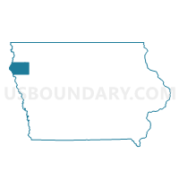
Outline

Summary
| Unique Area Identifier | 583030 |
| Name | UNION TWP Voting District |
| County | Plymouth County |
| State | Iowa |
| Area (square miles) | 35.80 |
| Land Area (square miles) | 35.80 |
| Water Area (square miles) | 0.00 |
| % of Land Area | 100.00 |
| % of Water Area | 0.00 |
| Latitude of the Internal Point | 42.69209170 |
| Longtitude of the Internal Point | -96.03742200 |
Maps


Graphs
Select a template below for downloading or customizing gragh for UNION TWP Voting District, Plymouth County, Iowa


Neighbors
Neighoring Voting District (by Name) Neighboring Voting District on the Map
- AMERICA TWP PART W/O LE MARS Voting District, Plymouth County, IA
- ELKHORN TWP W/O KINGSLEY Voting District, Plymouth County, IA
- GARFIELD TWP W/O KINGSLEY Voting District, Plymouth County, IA
- HENRY TWP Voting District, Plymouth County, IA
- LINCOLN TWP Voting District, Plymouth County, IA
- MARION TWP W/O OYENS & REMSEN Voting District, Plymouth County, IA
- REMSEN TWP W/O REMSEN PART Voting District, Plymouth County, IA
- STANTON TWP Voting District, Plymouth County, IA
Top 10 Neighboring County Subdivision (by Population) Neighboring County Subdivision on the Map
- America township, Plymouth County, IA (10,299)
- Remsen township, Plymouth County, IA (1,766)
- Garfield township, Plymouth County, IA (1,554)
- Marion township, Plymouth County, IA (600)
- Stanton township, Plymouth County, IA (352)
- Lincoln township, Plymouth County, IA (261)
- Elkhorn township, Plymouth County, IA (202)
- Union township, Plymouth County, IA (189)
- Henry township, Plymouth County, IA (173)
Top 10 Neighboring Unified School District (by Population) Neighboring Unified School District on the Map
- Le Mars Community School District, IA (13,465)
- Remsen-Union Community School District, IA (2,989)
- Kingsley-Pierson Community School District, IA (2,482)